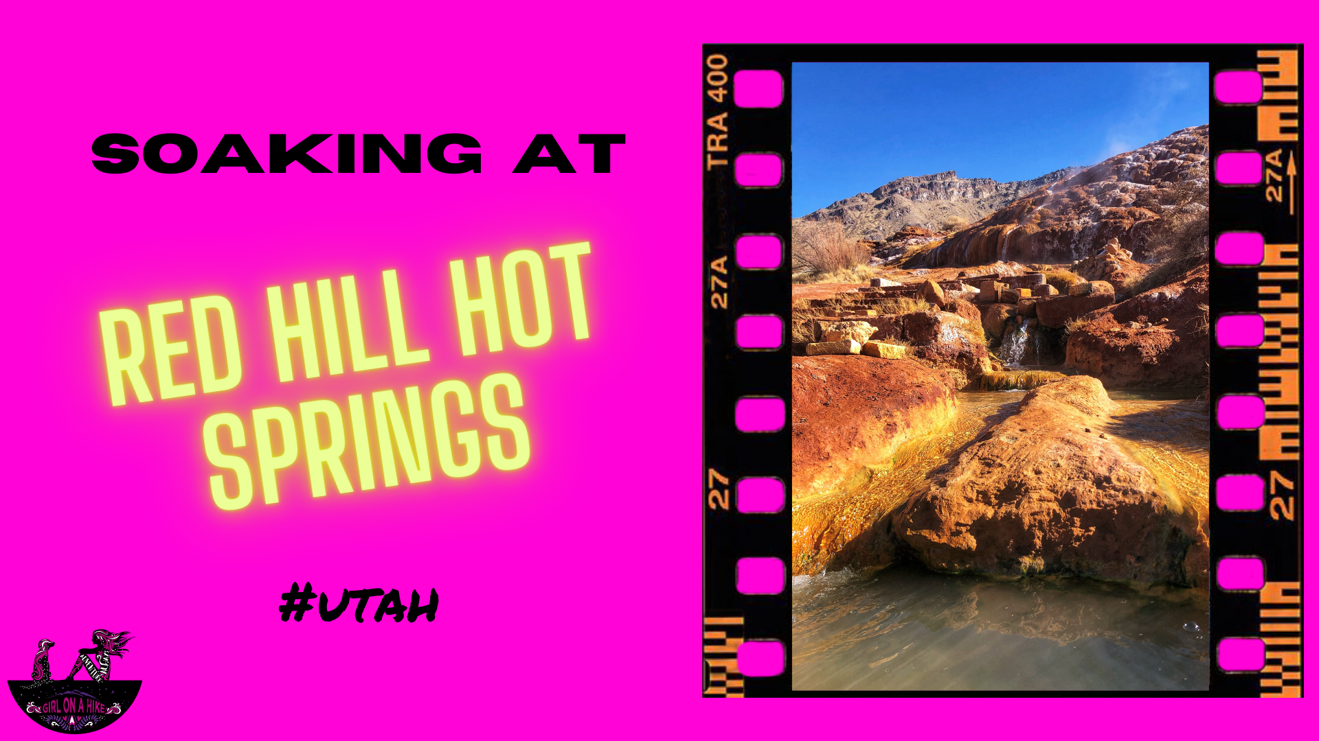
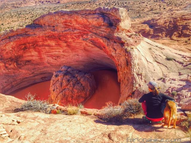
Top
  >  Destination Posts Archive
Southern Utah

Hiking to Mount Ellen & Mt.Ellen Peak

Mount Ellen (11,522 ft) & Mt. Ellen Peak (11,506 ft) are in the Henry Mountains, about 45 minutes - 1 hour south of Hanksville, UT. The Henry Mountains are an island of sort, as they are surrounded by three of Utah's National Parks - Capital Reef, Arches, and Canyonlands. Mount Ellen is a hulk of a mountain, composed of two distinct parts. The first is the North Ridge, which has the 3 highest summits in the Henry's.

Southern Utah

Hiking the Panorama Trail, Kodachrome Basin State Park

Kodachrome Basin State Park is located only 1 hour from Bryce Canyon National Park to the East, only 5 miles down the road from Willis Creek Slot Canyon, and 1 hour West from Escalante, Utah, yet hardly anyone visits this state park. With it's red rock formations and deep blue skies, the photography options are endless. Kodachrome Basin State Park opened in 1963, and National Geographic had the honor of naming it. It is home to 70 monolithic spires, ranging from 6-170 ft tall.

Southern Utah

Hiking to Five Hole Arch Colonnade Arch

Five Hole Arch (aka Colonnade Arch) is located south of Green River, UT off a rough 4x4 dirt road. The arch is so special it has two names - Five Hole Arch for the obvious five holes nature has created, and Colonnade Arch for the resemblance to Colonnade architecture (a row of columns supporting a roof). Some maps only show one or the other name, and some only label it as "Natural Arch". Whatever you prefer to call it, this arch is quite stunning once you find it.

Southern Utah

Hiking the Little Wild Horse & Bell Canyon Loop

Hiking the Little Wild Horse & Bell Canyon Loop is easy to navigate, the trail is well marked, it's usually free of standing water, the canyon walls are just wide enough for you to fit through, you can drive to the trail head in a small, compact car (most slot canyon entrances require a 4X4 car to get to the TH), you can hike this within a few hours, and it's like a fun maze for kids and dogs.

Southern Utah

Exploring the Yant Flat Cliffs, hike candy cliffs

The Yant Flat Cliffs is area is northwest of St. George down a dirt road that leads to a gorgeous view of red and orange rocks. This sandstone layer extends about 3 miles long at the southern boundary of a rocky plateau (Yant Flat), and the cliffs and buttes offer a variety of unusual striped rock formations. The wavy bands occur in shades of orange, red, pink, yellow, and white. Exploring the Yant Flat Cliffs (aka Candy Cliffs to locals) is relatively easy as you maneuver steep slopes across slickrock.

Southern Utah

Lodging at the Juniper Yurt, Monticello, Utah

The Juniper Yurt is located near Monticello, Utah and provides central access to many outdoor activities. The main hiking areas include Bears Ears/Cedar Mesa, Canyonlands (both year round), and the Abajo Mountains (summer only). The Juniper Yurt also has premier access to rock climbing, mountain biking, rafting, and more! Need some downtime? Just relax and disconnect for a while and borrow a book from their library to read in the cozy living room. This yurt also provides some the best star-gazing.

Southern Utah

Hiking Water Canyon, Hilldale, Utah

Water Canyon is a perfect desert oasis hike near Hilldale, UT. While this hike looks a lot like Zion National Park, it's dog friendly, perfect for kids, there are zero fees to enter, and you can make the hike as long or short as you want. I highly recommend hiking at least 1.5 miles to the small waterfall and pool area, so the dogs can cool off their paws and kids can explore and splash around.

Southern Utah

Hiking the Mansard Trail, Kanab, Utah

The Mansard Trail is located in Kanab, Utah and leads to a large alcove that is home to several petroglyphs. The trail itself winds its way up several gradual switchbacks before reaching a 6 ft scramble. Dogs and kids will need a boost, but otherwise the trail is quite easy. Halfway through you will reach the mesa, and the trail is mostly flat the rest of the way, but becomes very sandy.

Southern Utah

Hike Red Hollow Canyon, Orderville, Utah

Red Hollow Canyon is a very short slot canyon located in Orderville, UT. Because its only 1 mile round trip, this makes for a great stop for the drive in between SLC and Kanab to get the kids and dogs out for a stretch. The slot canyon section only lasts for about 0.2 miles but it offers some light scrambling (dogs and kids will need a boost), before ending at a tall dry fall.

Southern Utah

Hiking to Sunset Arch & Moonrise Arch, Grand Staircase Escalante National Monument

Sunset Arch & Moonrise Arch are two arches located within Grand Staircase Escalante National Monument (GSENM) off Hole in the Rock Road. They are both located in an area that does NOT have an official trail so being able to navigate a GPS is necessary. That being said it is pretty straight forward, and this easy hike is great for small children, dogs off leash, and those wanting to see something cool without the hard effort most hikes in this area require.

Southern Utah

Visiting Devil's Garden & Metate Arch, Grand Staircase Escalante National Monument

Devil's Garden is apart of Grand Staircase-Escalante National Monument, and is home to Metate Arch as well as hoodoos. Not to be confused with The Devils Garden Loop Trail in Moab, this area is only 640 acres and is part of a Wilderness Study Area, for the purpose of possible wilderness designation; however, wilderness status was not recommended by the BLM back in 1991. One of the reasons state was that the existing roads, parking lot, picnic tables, and port-a-potty are all in close proximity to a natural area. The second reason was the likelihood of several groups of people coming to this area at the same time to the same formations (all of which are within a 2 minute walk from the trailhead). Both of those reasons diminish the wilderness experience of solitude.

Southern Utah

Backpacking Kane Gulch to Bullet Canyon, Cedar Mesa

Backpacking Kane Gulch and Bullet Canyons are two popular routes in Bears Ears National Monument within Cedar Mesa, that require at least one night camping. This area is a mecca of ancient ruins and petroglyphs, deep within the canyon walls. Back in the day you wouldn't see people for days, however, with the increase of outdoor activities due to COVID you now can't go more than 2 miles without seeing other groups. This is not the area for solitude. Oh yeah, and there's another big issue...water.

Southern Utah

Hiking Upper Muley Twist, Capitol Reef National Park

Hiking Upper Muley Twist is located in Capitol Reef National Park (CRNP), and this route covers extremely varied terrain - from deep and narrow, to high and exposed, all within a relatively short distance. It begins in a canyon paralleling the spine of the Waterpocket Fold, a 100 mile long ridge that juts out from the upper crust of the landscape. This long "monocline" is one of the longest in the world! The bizarre landscape is made of brilliantly colored rocks, including at least 7 visible arches, natural bridges, slot canyons, fins, domes, and more. Hiking Upper Muley Twist gives you the grand tour of this area, so it's a must-do!

Southern Utah

Hiking to Wiregrass Canyon Arch, Lake Powell

Wiregrass Canyon is one of many drainages that flow into Lake Powell, and offers a fun moderate hike. If you had a full day, you could reach the shore of Lake Powell, but most people only hike to the arch and back in just a few hours. Wiregrass Canyon Arch isn't the only attraction - tall, white canyon walls with two sections of light scrambling make this enjoyable for the whole family. The first 1/2 mile winds through a dry wash, before entering the canyon, where the fun begins.

Southern Utah

Hiking to The Nautilus

The Nautilus is a delicate and beautiful rock formation made of wind and water eroded sandstone, at the edge of a small ravine near the Paria River, a mere 9 miles Northeast of The Wave. The Nautilus is an outcrop of a soft, thin-layered rock with a rippled surface texture, with the formation of a corkscrew-like gully. It's reminiscent of a conch shell, hence the term nautilus.

Southern Utah

Hike to Paul Bunyan's Woodpile, Utah

Paul Bunyan's Woodpile is an interesting geological feature in Central Utah, that looks like a "woodpile" of logs left behind by the giant lumberjack of American & Canadian Folklore. Really the woodpile is a cluster of lava rocks formed about 30 million years ago; the logs were then formed into orderly columns.

Southern Utah

Soaking at Red Hill Hot Springs, Utah

Red Hill Hot Springs is a popular soaking destination in central Utah, in Monroe. It consists of four pools, all fed by one very hot water source on top of the mound above the pools. Because this hot springs is free (and also on private property), it gets very crowded especially on weekends. The owners allow people to visit as long as the place is cleaned up after and not destroyed. This is a great place for families looking for a really nice hot springs that you don't have to hike it.

Southern Utah

Hiking the Cottonwood Wash Trail, San Rafael Swell

The Cottonwood Wash Trail is located in the heart of the San Rafael Swell, which offers two arches and several petroglyphs to view. It's a very easy hike, as the canyon is flat. The hardest part is walking up a 100 ft section of trail leading to the petroglyphs. That being said, this is a great canyon to explore with kids. The best time to visit is early Spring and late Fall when the day time temps stay below 70F - in October the Cottonwoods were bursting in yellow! 

Southern Utah

Camping & Exploring The Wedge Overlook

The Wedge Overlook is located in the San Rafael Swell only 3 hours from Salt Lake City. Often referred to as the "Little Grand Canyon", this destination offers expansive and stunning views similar to Grand Canyon National Park without the tourists, and fees, yet also allows dogs off leash. The Wedge was created from the San Rafael River carving into the terrain over millions of years. From the overlook you can see the San Rafael River, Window Blind Peak, Sid's Mountain Wilderness Study Area, and the lower Buckhorn Wash area.

Southern Utah

Hiking Sulphur Creek, Capitol Reef National Park

Sulphur Creek is located in Capitol Reef National Park and provides a beautiful water hike through a narrow canyon, with subway-like channels, cutting through layered, orange and red sandstone. It's considered the "Subway" or "Narrows" of CRNP, though really it lives up to its own name. The water is rarely more than ankle deep and there are three waterfalls that you can easily bypass, one forces you to slide down it's 5 foot drop!

Southern Utah

Backpacking Death Hollow, Escalante, Grand Staircase Escalante National MonumentDeath Hollow is located in Grand Staircase Escalante National Monument, just outside of Escalante, Utah. The first 6 miles of the trail follows the Boulder Mail Trail - the old route, that even up until 1924, the mules would carry mail on from the residents of Boulder, UT to Escalante, UT. Boulder, UT is right along Highway 12, which wasn't even paved until the 1970's, was the last area in the US to gain automobile access! No matter how much this area has changed due to technology, you'll immediately find yourself in the backcountry and won't see people for days. Over our 3 day adventure, my friend and I only saw two other people the entire time.

Southern Utah

Hike to Cascade Falls, Navajo Lake Utah

Cascade Falls is located near Navajo Lake, and is in fact, a major drainage port for the lake. The trail offers amazing view of Zion National Park on a clear day, and all ages and all types of hikers plus dogs will enjoy this area. The water from the falls is supplied by the lake through an underground lava tube (sink hole). The water flows through this for a few miles underground before exiting at the Virgin River Rim.

Southern Utah

Brian Head Peak, Iron County High Point

Brian Head Peak (11,307ft) is the Iron County High Point, and located at Brian Head Ski Resort. There is no hiking, but rather a very casual walk to the summit that even kids can do. It's a great place to take visitors and tourists to "bag" a peak they can literally drive to and have amazing views of the area. The gate to drive to the summit is typically open June though October, or whenever it's free of snow and dry. Even in summer the temperatures can be quite chilly up there at that high of elevation. Bring a light jacket and a camera, and check out the views!

Southern Utah

Hiking to Andy Nelson Peak & Kane County High Point

The Kane County High Point (10,080 ft) is located on a small ridge similar to the Wasatch County High point, rather than on an actual peak. The highest actual peak, Andy Nelson Peak (10,027 ft) is nearby so it is worth to do both on the same day. In one day, we actually did the Kane CoHP, Andy Nelson Peak, hiked Cascade Falls, drove through the lava fields, and then drove to the Iron County HP (Brian Head Peak). 

Southern Utah

The 6 Best Trails in The San Rafael Swell

The San Rafael Swell is a mecca of hiking and camping, all free thanks to BLM Land. It's a great area to explore off trail, find rock art, hike through slot canyons, and traverse over red and white slick rock. The Swell offers something for everyone, so it's great for the whole family, kids, and dogs included. The best times of year to hike here are early Spring and late Fall when the temperatures are cooler. From arches to the best views, here are the 6 Best Trails in the San Rafael Swell!

Southern Utah

Hiking Farnsworth Canyon, San Rafael Swell

Farnsworth Canyon is located in the San Rafael Swell, and offers a little something for everyone. A short slot canyon, pictographs, exploring off trail, and desert flowers in the Spring all abound. Hiking to the pictographs is only 1.5 miles one way, so even kids can enjoy this hike and "hunt" for the pictograph. Farnsworth Canyon does extend much further, to the other side of the reef, but most people turn around at 1.5 miles. There is zero shade or water, so start early to beat the heat. The slot canyon is very easy to walk through, and nothing technical is required so it's great for beginners.

Southern Utah

Hiking to the Hurst Natural Bridge, San Rafael Swell

Hurst Natural Bridge is located in the San Rafael Swell, high above Ernie Canyon. There is no trail to reach Hurst Bridge, making a fun day for those who like adventuring and exploring. Make sure you have a downloaded topo map of the area, as there is no cell service. There is no shade, nor water so be prepared to be self-reliant. This is a dog friendly hike, but the sand will burn their paws if you start too late - we started hiking at 10am and I wished we had started no later than 7-8am.  This hike is best during Winter, early Spring and late Fall when the temperatures have cooled off. If you like hiking to lesser known ares of The Swell, this is the trail for you!

Southern Utah

Hiking the Anazasi Trail (Tempi'po'op), St.George, Utah

The Anasazi Trail (aka Tempi'po'op, which means "rock writing" in Southern Paiute) in St.George is a casual trail that leads to ancient Pueblo & Paiute remains, as well as petroglyphs. This is more of a walk, rather than a hike, and is great for the whole family to do since it is only 2.2 miles RT. There is zero shade nor water, and the trail gets hot quickly. If you bring your dogs make sure to start early in the day so they don't burn their paws. The path itself consists of long switchbacks, which lead you to a very small hill where the old farmstead was located, and is now fenced off. After checking that out, continue walking uphill (to the South) to see the petroglyphs. 

Southern Utah

Hiking the Red Mountain Trail, St.George

The Red Mountain Trail is located in Dammeron Valley, UT not far from Sand Hollow and Gunlock State Parks. Because it's not actually apart of the state parks and is wilderness area, dogs are allowed off leash. Be sure to start early in the morning so the sand doesn't burn their paws. The first 1.5 miles of the trail is very boring and uneventful, but what the trail does lead to is amazing. The Red Mountain Overlook looks down into Sand Hollow, and the white and red slick rock with Signal Peak in the Pine Valley Mountains to the East is incredibly beautiful. This trail is great for the whole family, as it only gains a mere 360 ft. It's a mix of sand and rock, but plenty of shade if you do need a break.

Southern Utah

Lodging Review: Circle D Hotel, Escalante , Utah

Circle D Motel is located in the heart of Escalante, Utah - an outdoor lovers paradise for hiking to slot canyons, canyoneering, backpacking, and exploring natural arches off Hole in the Rock Road. The area is rich with history and beautiful scenery, which is apart of Grand Staircase-Escalante National Monument (GSENM). My dog and I come here to explore the trails, but sometimes it's too cold for camping, especially in winter. That's when we call up Circle D to make sure we have a warm, welcoming room when we arrive tired and dirty from exploring outside.

Southern Utah

Hiking to Deer Creek Lakes, Boulder Mountain, Hiking on Boulder Mountain, Utah

Deer Creek Lakes sits high on Boulder Mountain at 10,000 ft, and several other nearby lakes are accessible as well including Green, Chriss, and Mooseman Lakes. All of these lakes provide for an excellent day hike, quick overnight backpacking trip, and plenty of fishing and sightseeing. The trail to get to Deer Lake is only 2.8 miles one way, and is fairly easy and flat. Over the 3 miles you only gain about 700 ft, making it a gently incline the whole way. Keep in mind that you will be hiking at a high elevation, and that can often slow hikers and dogs down. Take your time - the views from Deer Lakes is amazing and well worth the effort.

Southern Utah

Cedar Wash Arch & Covered Wagon Arch, Escalante

Cedar Wash Arch & Covered Wagon Arch are in Escalante, Utah, off Hole in the Rock Road. Each are very short in distance making this perfect for little kids, families, and dogs. Combine these arches with other hikes in the area to make a day of it. This isn't really a "hike", but rather a quick walk. Visiting both will only take about 30 minutes combined, plus the drive.

Southern Utah

Hiking to the Seven Kivas Ruin via Shortcut Route

The Seven Kivas Ruin is located in Cedar Mesa, off Cigarette Springs Road. A kiva is a subterranean ceremonial chamber, and have been central to Native spiritual traditions since ancient times. The interesting thing about kivas, is that one of them could serve a single family. To have seven kivas in one area meant this site was used for something very sacred.

Southern Utah

Exploring the Comb Ridge Canyons & Ruins, Cedar Mesa

Comb Ridge is a 90-mile long Navajo sandstone ridge (or monocline) running North to South, and is home to many ancestral ruins and petroglyphs that date back around 800 years old. Comb Ridge itself has a gentle eastern facing slopes, while the west side has "teeth" that jut out and above the ridge line. Each of these "teeth" contain drainages that lead to the San Juan River. The Puebloans lived, farmed in this area, and left behind a massive amount of ruins and artifacts. Drought, overpopulation, diminishing resources, erosion, and conflict eventually brought an end to this era.

Southern Utah

Backpacking Halls Creek Narrows, Capitol Reef National Park

Backpacking Halls Creek Narrows is located within Capitol Reef National Park, only a few miles North from Lake Powell. This area of the park sits between the high cliffs of Hall Mesa on the East, and the Waterpocket Fold on the West. As you backpack towards Halls Creek Drainage (aka Grand Gulch), you'll be surrounded by red, white, and orange slick rock, all while hiking through a mostly sandy trail.

Southern Utah

Backpacking Fish & Owl Canyons, Cedar Mesa & Bears Ears National Monument

Fish and Owl Canyons, located in the Cedar Mesa area of Bears Ears National Monument, is a popular loop hike for backpackers looking to discover ancient ruins and kivas, hike through desert terrain, visit Neville's Arch, and explore two scenic, deep canyons. This area is recommended for intermediate to advanced backpackers due to the distance, rugged terrain, light route finding and scrambling.

Southern Utah

Hiking to Blind Lake, Boulder Mountain

Blind Lake is located on Boulder Mountain in Utah - it is the deepest and biggest lake on the mountain at 52 acres and 52 feet deep. Most people come to the lake to fish for trout, but there the trail itself is great for dogs, kids, and families. It's only 1 mile to reach Blind Lake, but you can continue on to Pear & Fish Creek Lake, and the Beaver Dam Reservoir.

Southern Utah

Hiking the Behunin Trail & Meeks Lake Loop, Boulder Mountain

The Behunin Trail and Meeks Lake Trail are both located on Boulder Mountain, Utah, and are often done as separate hikes. However, you can combine them into one big loop to really see the East side of Boulder Mountain, and on clear days, all the way to the Henry Mountains. First, you'll hike up to "Boulder Top", the ridge, where you'll cross several open meadows, a stream, and will pass by an old airplane crash. Then you'll make your way over to Pleasant Lake, which offers great trout fishing and refreshing cooler temperatures, since the lake is at an elevation of 10,300 ft. After that, you'll hike over to Meeks Lake, another popular lake, and though it's pretty, doesn't have many fish. At the end of the day, you'll drop down the Meeks Lake Trail, and make your way through more meadows, and end back at your car.

Southern Utah

Backpacking the Ashdown Gorge via Rattlesnake Creek

The Ashdown Gorge is located on the boundary line of Cedar Breaks National Monument, and lies within the Ashdown Gorge Wilderness near Cedar City, Utah. The trail starts by following the Rattlesnake Creek Trail at 10,500 ft, and eventually drops into the gorge descending a total of 4,100 ft. This route is best done point-to-point, with 1 over night backpacking. You can definitely do this in one day, but to really experience the canyon and take your time, backpacking this trail is perfect.

Southern Utah

Hiking the Butch Cassidy Trail, Red Canyon near Bryce Canyon National Park

Red Canyon is located off HWY 12 near Bryce Canyon National Park, which compared to its famous neighbor, sees half the visitors. And for good reason - there's no national park name attached it, and many people do not realize how many trails are in the canyon. In particular, the Cassidy Trail, is one of the best in the canyon. No fees, dog friendly, shade, and amazing views all located in the Dixie National Forest - does it get any better?

Southern Utah

Hiking Pine Creek (The Box Trail) in Escalante, Utah, Hiking in Grand Staircase Escalante National Monument, Hiking in Utah with Dogs

Pine Creek Canyon is a hidden gem in the Escalante area - a pristine creek, tall canyon walls, half mountain-half desert, no cows, all downhill, plenty of shade, and towering Ponderosa trees. Located in the Box-Death Hollow Wilderness, this canyon is also known as "The Box", which is funny since it's not really a box canyon but steep-walled, open-ended drainage carved by Pine Creek millions of years ago.

Southern Utah

Bowington Arch Grand Staircase Escalante National Monument (GSENM), Hiking with Dogs in Utah

Bowington Arch is located in Grand Staircase Escalante National Monument (GSENM) near the town of Escalante, UT. It's an easy hike that crosses the Escalante River several times, and therefore it's important to wear water shoes. You will also hike through sandy sections with sage brush and cottonwood trees. Bowington Arch is dog-friendly and (possibly) kid friendly. There are no obstacles of any kind except for one small scramble the the dogs can easily do, and some younger kids might need help with. I say possibly kid friendly since this trail is close to 8 miles round trip, but is completely flat the whole way. Make sure you have a map of the area downloaded on your phone or GPS, as there is no sign for where to turn off for the arch. I highly recommend the Gaia GPS app.

Southern Utah

Backpacking the Escalante River Trail, Grand Staircase Escalante National Monument

The Escalante River Trail is a popular backpacking point-to-point route near the town of Escalante, Utah and within Grand Staircase Escalante National Monument (GSENM). The entire length of the Escalante River is 87 miles, but this route allows you to see 15 miles of it overnight one night of backpacking. Much of the way, your path will be the river itself.

Southern Utah

Hiking to Cassidy Arch & the Frying Pan Trail, Capitol Reef National Park

Cassidy Arch is located in Capitol Reef National Park, in the heart of the Waterpocket Fold, a 100-mile monoclinal flexure (simply, a "buckle") in the earth's upper crust. It runs North to South, all the way down to Lake Powell. Along the Fold, rocks have been pushed up and erosion has cut through layers creating deep, narrow canyons and formations. Cassidy Arch, named after Butch Cassidy, is roughly 40 ft across near the top of the arch and the trail provides amazing views of the Grand Wash/Capitol Reef area.

Southern Utah

Exploring Fantasy Canyon, Vernal, Utah. Hiking in Utah with Dogs, Hiking in Utah with Kids, Camping near Vernal, UT

Fantasy Canyon is about an hour south of Vernal, Utah and is a small, but unique area consisting of grayish-brown sandstone. Most of the main erosion direction is horizontal and resembles irregular stacked planks, bones, or thin pinnacles. Keep in mind that these formations are extremely fragile - don't break off pieces or take them home. Most of the formations occur on the north side of the mesa, centered along a narrow ravine only 200 ft long and up to 20 feet deep. Exploring this area is really interesting and fun, but it is really small. Plan on combining visiting Fantasy Canyon with other hikes in the Vernal area to make it a worthwhile trip, If you plan on only coming out here to see Fantasy Canyon, you may be disappointed.

Southern Utah

Hiking to Phipps Arch, Grand Staircase Escalante National Monument

Phipps Arch swoops through Grand Staircase Escalante National Monument affording constant view of bizarre and beautiful land, as hikers search for this hidden arch. There is no official trail - getting to the arch requires a little research and planning. This is a hike you definitely want to have a GPS for. Because this is a trail-less approach, you will rarely see many people hiking here because it's not nearly as popular as its neighbor trail, Lower Calf Creek Falls.

Southern Utah

Hiking to Broken Bow Arch, Hiking in Grand Staircase Escalante National Moument, Hiking in Escalante with Dogs, Hiking to natural arches

Broken Bow Arch is located off Hole in the Rock Road (HITR), 41 miles south of Escalante, UT. Broken Bow spans nearly 100 ft, and sits in the middle of Willow Gulch. This trail is more popular among backpackers looking to reach Fortymile Gulch as well. This hike can be done in a loop, but is just as good as an out-and-back hike at 4 miles RT. 

Southern Utah

Hiking Zebra Slot Canyon, Hiking Utah's best slot canyons, Hiking in Grand Staircase Escalante National Monument

Zebra Slot Canyon is located off of Hole in the Rock Road, near Escalante, UT. The hike is only 2 miles in, and the best section of the striped walls only lasts for about 100 ft. Getting to the slot is quite easy, as it meanders through Juniper & Sage brush, cuts through a beautiful red rock canyon, then open up as you walk through the sandy dry wash, and eventually leads to the iconic striped walls resembling zebra stripes.

Southern Utah

Hiking Spooky & Peekaboo Slot Canyons (Loop), Hiking in Escalante, Utah, Hiking in Escalante with Dogs, Hiking slot canyons

Spooky & Peekaboo are the most popular slot canyons in the Escalante area. The access is easy, you can easily do both as a loop in a few hours, and hikers without technical canyoneering equipment or skills can enjoy both. Spooky slot canyon is one of the narrowest canyons in the world that hikers can safely navigate. It's much longer and slimmer than Peekaboo, forcing hikers to carry daypacks to the side as you shuffle through. Add in a few short obstacles and one 5 ft scramble to make it that much more fun. Claustrophobic people will have a hard time with this Spooky.

Southern Utah

Hiking to the Rochester Panel & Molen Reef Petroglyphs

The Rochester Panel and Molen Reef Petroglyphs are near Emery, Utah, and consists of one very large panel of hundreds of images likely carved by the Fremont Native Americans. The vast majority of the petroglyphs have a strong Barrier Canyon influence, including animals, female/male figures, and one large rainbow-like image. Molen Reef Petroglyphs are much smaller, but still expose what the native people were contemplating. You can easily combine both in one afternoon, as the hike to the Rochester Panel is only 1/2 mile, and you can drive right up to the Molen Reef area. Kids, dogs, and casual hikers will enjoy these areas, but please respect the rules and DO NOT touch any of the petroglyphs.

Southern Utah

Exploring the Swasey Cabin & Lone Warrior Pictograph

The Swasey Cabin and Lone Warrior Pictograph are located in the San Rafael Swell west of Green River, UT. The area is rich with history that includes Butch Cassidy and "The Wild Bunch", as well as Native American rock art. The Swasey Cabin was built in 1921 with Douglas Fir logs, and belonged to Joseph Swasey and his family who farmed and ran livestock in the "heart of Sinbad Country", according to the BLM.

Southern Utah

Moonshine Arch is located about 7 miles north of Vernal, UT. Not to be confused with the Moonshine Wash Slot Canyon in the San Rafael Swell, this short trail leads to an amazing arch that is 40 ft high, and 85 ft long. The trail is 90% sand and 10% slickrock, so because of this I highly avoid hiking here in Summer months if you bring your dog (the sand/rock will be too hot for their paws). The best time to hike here is in the afternoon, when the sun lights up the arch and alcove. This trail is super short, so it's great for kids or families visiting from out of state to hike to. Be aware that this trail crosses through an open cattle range, so always have a leash handy and don't disrupt the cattle or other wildlife.

Southern Utah

10 Tips for Backpacking Buckskin Gulch, Backpacking Buckskin Gulch with Dogs

Here are 10 tips for backpacking Buckskin Gulch! Backpacking Buckskin Gulch is a one of a kind adventure - not only do you get to travel through the world's longest and deepest slot canyon, but you have some of the most amazing views of long hallways with rocks towering 200-300 ft above you, hiking through dark sections of molded rock, climbing over obstacles, but also get to experience camping overnight in this amazing area. While this canyon has been nicknamed the "worlds most dangerous hike" it also often appears as one of the top "must-do hikes" in the world! As long as you go prepared, it's a trip of a lifetime!

Southern Utah

Hiking to Signal Peak, Pine Valley Mountains, Washington County High Point

Signal Peak (10,365 ft) is the high point for both the Pine Valley Mountains and Washington County. It you are a peak bagger looking to summit all of Utah's County High Points, you'll be hiking this one. The main route starts from the Oak Grove Campground, and follows the trail up the South ridge very steeply, before dropping into forested areas, and then hiking off trail to reach the summit.

Southern Utah

Hiking The Narrows, Zion National Park

The Narrows in Zion National Park is a must-do hike for any hiker looking to experience a slot canyon, hiking through water, and see gorgeous views that Zion is known for. You will not, however, have solitude as The Narrows is one of the most popular hikes in the Southwest, and especially in Utah. As the name "Narrows" implies, it's the narrowest canyon in Zion Canyon at only 20 feet wide and canyon walls over 1,000 ft high. This all time classic hike should not be missed on your trip to Zion!

Southern Utah

Hiking the Moonshine Wash Slot Canyon San Rafael Swell

Moonshine Wash slot canyon is tucked away in the middle of the San Rafael desert, and is now one of my favorite non-technical slot canyons in Utah. The best section of the Moonshine Wash slot canyon lasts for about 1.5 miles, and at every nook and cranny the lighting can look very different and vibrant. There are a few chock stones creating a fun obstacle for hikers, where you have to use a down climbing technique called stemming (also chimneying). Both techniques require you to push your weight up against the slot canyon walls to help maneuver down drops more than 6 ft.

Southern Utah

Backpacking to Reflection Canyon, Lake Powell, Utah

Reflection Canyon is a side canyon of Lake Powell that was first brought to the public's attention when National Geographic photographer, Michael Melford, took an amazing photo of this canyon and wrote the article, Glen Canyon Revealed. Since then, Reflection Canyon has slowly become popular over the years as a "must see" location for photographers, backpackers, and hikers looking to explore this secluded area.

Southern Utah

The End of Hole in the Rock Road, Camping at the End of Hole in the Rock Road, Southern Utah

Hole in the Rock Road runs from Escalante, Utah to the actual Hole-in-the-Rock on the Western shore of Lake Powell. It's a 62 mile dirt road that follows the general route of the original Hole in the Rock Expedition, when the Mormon trailblazers crossed the Colorado River and ended their journey in Bluff, Utah. The Hole in the Rock expedition established the trail in 1879, and has since become part of Grand Staircase-Escalante National Monument, Glen Canyon National Recreation Area, and within BLM Land.

Southern Utah

Hiking the Lower Hackberry Canyon Narrows, Cottonwood Road Scenic Byway, Grand Staircase-Escalante National Monument

Lower Hackberry Canyon is located in Southern Utah of the famous Cottonwood Road Scenic Byway, in between Cannonville and Big Water, Utah. It's rarely visited since you need to drive down a dirt road to get to the trailhead. However, it's now one of my favorite large slot canyons to hike for a few reasons: 1) the water is never more than ankle deep and makes for a great water hike 2) dogs are allowed and also enjoying playing in the water 3) no matter what your level/skill of hiking is everyone can do this hike 4) you'll likely see no people and 5) you can choose your distance.

Southern Utah

Hiking at Hovenweep National Monument

Hovenweep National Monument is home to six prehistoric, Pueblo villages spread over a 20 miles range of mesa tops and canyons along the Utah-Colorado border. Multi-storied towers perched on canyon rims and balanced boulder lead visitors to marvel at the skill and motivation of the builders. The trail system at Hovenweep provides excellent views of all the archaeological sites.

Southern Utah

Today's Guest Post is brought to you by Mitch Stevens, the founder and lead guide of Southwest Discoveries

Take a Hike - 7 of the Grandest Adventures in the Southwest

These trips of a lifetime will challenge you physically and engross you spiritually, leaving an unforgettable and enduring impression of the richest wild places on the planet. The southwest contains literally thousands of amazing hikes. Therefore, we decided to separate the wheat from the chaff and give you the absolute cream of the crop. We rounded up 7 of the grandest adventures in the southwest, treks we have experienced firsthand.

Southern Utah

Hiking Mt. Pennell, Henry Mountains, Utah

Mt. Pennell (11,371 ft) is the 3rd highest point in the Henry Mountains, coming in after Mount Ellen and Mt. Ellen Peak. The Henry Mountains are off the beaten path for most hikers, but the range itself is a peak baggers dream! 5 of Utah's 81 prominence peaks are found in the Henry's: Mount Ellen (#3), Mt. Pennell (#26), Mt. Hilliers (#32), Mt. Ellsworth (#42), and Mt. Holmes (#64); the last two peaks are also known as the "Little Rockies." Take a few days to spend here, and you could knock out all five peaks.

Southern Utah

Backpacking Coyote Gulch, UtahCoyote Gulch in Southern Utah is one of many quintessential red rock canyons of the Escalante River drainage. Containing several natural arches, natural bridges, petroglyphs, cascades, waterfalls, and pure beauty, Coyote Gulch is one of the most scenic canyons in Utah. Coyote Gulch could be hiked in one day, but why rush? With all that the canyon has to offer, plan on spending at least one night minimum backpacking. Two nights will really allow you to take in the massive canyon walls, sparkling stream, and breathtaking scenery.

Southern Utah

GUEST POST by Katie Wanders Katie Wanders follows New England native, Katie, around the globe. Katie swapped her oceans for mountains and moved to Utah for two years to see what "Life Elevated" was all about. Katie Wanders follows trips around the American West, adventures along the coasts, trips abroad, and showcases her love of New England. Currently, you can find her in a 2016 Penske truck with her dog and cat, wandering around National Parks and making her way back to the Atlantic. You can follow all of her adventures on FacebookInstagram, and Pinterest!

Utah's Might Five National Parks

Southern Utah

Mule Canyon and House on Fire ruins, Utah cliff dwellings, Bears Ears National Monument

The famous "House on Fire" ruins lie Mule Canyon, in between Natural Bridges National Monument and Blanding, Utah. Southeast Utah is home to the most numerous and varied collection of ruins, spread over a remote area of about 30 X 25 miles. Besides hundreds of ruins, mostly cliff dwellings, the Cedar Mesa area contains many petroglyphs and pictographs, all between 800 - 2000 years old from the Anasazi and Pueblo Indians. Most are found in canyons, where water was easily accessible and conditions were cooler in summer months. All land is public, managed by the BLM, and as of  2016 is protected under the Bears Ears National Monument.

Southern Utah

Goosenecks State Park, Camping at Goosenecks State Park, Utah

 High above the meandering San Juan River, lies Goosenecks State Park. This largely undeveloped park is home to a rare geological featured known as the Entrenched Meander. This refers to a river that is confined to a canyon or gorge, and in most cases is narrow with very little or no flood plain. The headwaters of the San Juan River are in the San Juan Mountains of Southwestern Colorado, which is the origin for 90% of the rivers' flow. The river flows 360 miles from its source, starting at an elevation of 14,000 ft and dropping to just 3,600 ft at Lake Powell.

Southern Utah

Fremont Indian State Park, Utah

After our visit to Mystic Hot Springs, we drove west down I-70 for another 20 minutes until we reached Fremont Indian State Park. Thousands of years ago this area was home to the largest population of Fremont Indians. Many petroglyphs (engraved rock with symbols) still exists, and the park offers a small trail system to view them. Inside the museum are artifacts, a film, petroglyph tours, hands-on activities for kids, and exhibits that reveal the lives of the Fremont. The park also offers RV and tent camping, you can rent out a Tipi, and there's also access the famous Paiute ATV Trail.

Southern Utah

Mystic Hot Springs, Monroe, Utah

 Mystic Hot Springs is located in Monroe, Utah, about a 2.5 hour drive south of SLC. It's been on my Utah Bucket List for awhile, so a few friends and I made it happen this weekend as a day trip. Among all of the hot springs in Utah, this is by far the most unique and least crowded, but also the most expensive. The natural hot springs flow into 6 large bathtubs, and two smaller, shallow pools. The closer you soak to where the water flows from, the hotter the water is. Mystic Hot Springs has been around for nearly 100 years, and has changed owners a few times. Originally, the hot springs were where the Indian tribes of Ute, Shoshone, & Piute would set up camp, and soak for warmth and comfort. Legend says that they would paint themselves with the red dirt to keep themselves safe.

Southern Utah

Goblin Valley State Park

Goblin Valley State Park feels like another world - most say it resembles what would be Mars, however the park sits at the northern end of the San Rafael Swell. The hoodoos ("goblins") are mushroom-shaped pinnacles that are only a few feet high. The formations have large orange/red boulders of hard rock on top, with weaker sand layers below that have eroded more quickly over millions of years from the combined effects of rain and wind.

Southern Utah

Spotted Wolf Canyon overlook

Spotted Wolf Canyon is located off I-70 at the Northern end of the San Rafael Swell, which makes up about 1/4 of Utah. "The Swell" as us Utahns call it, is what most people think of when they think of Utah. The arid area, with little vegetation is often very scenic, with mesas, cliffs, buttes, springs, and many canyons; these are sometimes wide or can be very narrow such as Little Wild Horse Canyon. Most of the swell is owned by the BLM and encompasses 2,000 square miles! This is great for 3 main reasons in my opinion: 1) the land is protected and will not be built on 2) dogs are allowed off leash 3) you can camp almost anywhere, for free!

Southern Utah

The Wave

 The Wave is a hiker & photographers dream destination! The smooth, unique rock formations make for an unforgettable experience. The Wave has become so popular in the last few years due to social media, photographers, and many articles naming it one of the "coolest", "most unique", "most isolated", most blah blah places on earth! And it really is. However, people don't do their research before hiking here and many have needed to be rescued or have even died while gone missing. Why? The reason is because they go unprepared. There is no trail, the temperatures can be up to 115 degrees in summer, and people don't bring enough water and food.

Southern Utah

The Subway, Hiking The Zion Subway, Zion National Park, Utah

The Subway in Zion National Park is a hiker and photographers dream destination! The Subway follows the Left Fork Canyon in Zion NP, and along the way you'll have a vast view of the canyon, you'll walk along the river and hike by several deep pools, and hike where only 80 people are allowed in each day. After living in Utah for 2 years, I finally got the opportunity to go by applying (and winning) a permit.

Southern Utah

Kanarra Falls

Kanarra Falls is a great Utah waterfall hike. You get to hike in a very accessible and beautiful slot canyon, a chance to walk in the river on a hot day, and see several beautiful waterfalls. The biggest downside to this hike is the crowds - it has become a big issue in the past year or so (read about the issues going on here). Kanarra Falls is the perfect stop for amateur photographers looking for professional photo opportunities. This is also a great family hike - it requires only a 2-3 hours, no equipment or gear is needed, nor a high level of hiking skill. Even the kids will love this hike! You'll want to be sure to wear sturdy, water shoes as most of this hike is in the river.

Southern Utah

Kayenta Canyon

Kayenta Canyon Trail is known by two names: Kayenta Canyon, and to the locals, Hellhole Canyon. This trail starts in the town of Ivins, UT, about 15 minutes west of St. George, UT. If you don't like walking in sand washes, this is not the trail for you. 90% of this trail is walking in the wash, and on a sunny day (most days in Southern Utah), it can get very hot. There is no water, no shade, and no restrooms.

error: Content is protected
Skip to content