logo dark logo
  • Dog Friendly Lists
  • Find a Hike
  • Discount Codes
  • Fav Gear
  • About
    • Testimonials
    • Awards & Features
Mobile Logo
  • Dog Friendly Lists
  • Find a Hike
  • Discount Codes
  • Fav Gear
  • About
    • Testimonials
    • Awards & Features
Top
Home  >  Hiking   >  Exploring White Pocket, Vermillion Cliffs National Monument
Southern Utah

Exploring White Pocket, Vermillion Cliffs National Monument

Hiking
Share the love!
Shares

Hiking to Smith Lake via Angel Lake Trail, Nevada

White Pocket is a beautiful area for outdoor lovers in search of Navajo Sandstone, including domes, hoodoos, potholes, and more. It’s located in a 20 by 20 mile zone, within the Paria Plateau and Vermillion Cliffs National Monument. Hiking around and exploring White Pocket is easy – it’s the drive that is the hard part. 

Contents hide
1 Share the love!
2 About
3 Directions
4 Trail Info
5 FAQs
5.1 When is the best time of year to go?
5.2 What tour should I do?
5.3 How should I pack for this?
5.4 Is this a good trip/area for kids and dogs?
5.5 What if I want to drive myself and not take a tour?
5.6 Can I camp here?
5.6.1 Check out my video!
6 Nearby Hike
7 Save me on Pinterest!
7.1 Share the love!


About

I’ve been wanting to come here for years. But the issue is the long, deep sandy drive to get there. You have to have good clearance, legit 4WD, know how deflate your tires, know how to navigate the unmarked roads, plus have good driving skills for the sand. For this reason, I have never been able to go. My car does have the clearance and 4WD, but I don’t have experience driving in sand and didn’t want to risk getting stuck or ruining my car in the middle of nowhere. I would much rather drive in a foot of snow over sand! So for 2020 I decided I was going to finally do this! 
My friend hired a tour company last year, and highly recommend we go with Dreamland Tours. I wasn’t comped or given special to access to anything, and I paid my own money to go on tour with them. And it was well worth it! We took the Full Day White Pocket Tour, and our tour guide was Bret was recommended by my friend, so we requested him and we had the best time! He knew all the cool places to stop along the way, knows the roads by heart, taught us a lot about the history and geology, showed us the cool angles of all the rocks and how to take the photos, and was just really relaxed and fun. It was SO much better to go with someone who knows all this stuff rather than do it solo and not know what we were looking at.

Directions

Due to the unmarked roads, deep sandy ruts, and potential for getting stuck/lost, I am not posting directions here. Please reach out to a tour company for the best route to drive here.

Trail Info

Distance: Varies

Elevation gain: ~200 ft

Time: 6-8 hours, including drive time from Kanab, UT

Dog friendly? Yes, off leash

Kid friendly? Yes, all ages

Fees/Permits? None to explore, however if you take a tour you will need to pay for that depending on the tour company

FAQs

When is the best time of year to go?

Spring and late Fall are best due to mild temperatures and dry roads. Summer is monsoon season so there is a risk of getting stuck on a very muddy road, and in Winter the snow covers all the rock formations making photos less appealing and you can’t really see everything.

What tour should I do?

This will vary based on what you want to see. For this blog post and our tour, we did the Full Day White Pocket Tour, however they offer all kinds of full-day tours plus overnight trips.

How should I pack for this?

Pack like you are going on a 6 mile hike. They do provide you a sandwich and one water bottle, but I also brought my own snacks, 2.5 liters of water, sunblock, and I dressed in layers.

Is this a good trip/area for kids and dogs?

Absolutely, both! Since little hiking is required and this is an explore-on-your-own area, this is great for kids of all ages. Dogs are welcome here off leash as well, however I would avoid going in the summer as the sand and slickrock can burn their paws and they have a higher risk of dehydration. Dog poop needs to be packed out. Since we took the tour, we couldn’t bring our dogs.

What if I want to drive myself and not take a tour?

Most people do! Just be prepared with a satellite communicator like a ZOLEO, detailed road map, water, gas, and food. Know how to deflate your tires for the sand, and have the gear to get pulled out if stuck.

Can I camp here?

Yes, this is all on BLM Land so camping is free. Just try to pick a spot that has been previously been used. The best spots are right near the White Pocket “trailhead”.

Let’s get to exploring!

Exploring White Pocket, Vermillion Cliffs National Monument

Entering the official White Pocket area!

Exploring White Pocket, Vermillion Cliffs National Monument

There’s no “trail” here – just explore on your own.

Exploring White Pocket, Vermillion Cliffs National Monument

Around every corner is something even prettier.

Exploring White Pocket, Vermillion Cliffs National Monument

See the indents in the rock? That is from horses consistently going over to a water hole back in the day. On our trip it was completely dry.

Exploring White Pocket, Vermillion Cliffs National Monument

Bret teaches us about the history and geology of the area. He’s been guiding with Dreamland for over 10 years!

Exploring White Pocket, Vermillion Cliffs National Monument

Listening in on Bret’s knowledge.

Exploring White Pocket, Vermillion Cliffs National Monument

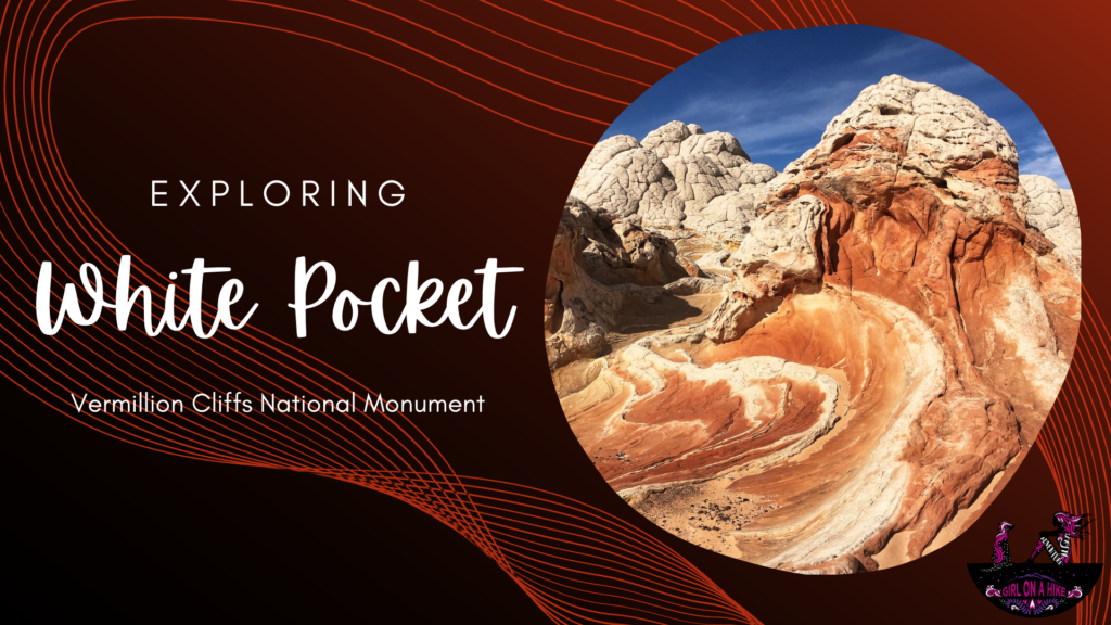
Just wow! So many cool rock formations.


Exploring White Pocket, Vermillion Cliffs National Monument

White Pocket is a great spot for many photo opportunities. It’s actually a ver popular spot for astrophotography as well. That’s above my skill level haha!

Exploring White Pocket, Vermillion Cliffs National Monument

Exploring White Pocket, Vermillion Cliffs National Monument

Exploring White Pocket, Vermillion Cliffs National Monument

Exploring White Pocket, Vermillion Cliffs National Monument

Notice how the stripes aren’t perfectly in line? That represents an earthquake that moved the perfect rock lines millions of years ago.

Exploring White Pocket, Vermillion Cliffs National Monument

Exploring White Pocket, Vermillion Cliffs National Monument

Exploring White Pocket, Vermillion Cliffs National Monument

Exploring White Pocket, Vermillion Cliffs National Monument

Another area with the horse tread in line.

Exploring White Pocket, Vermillion Cliffs National Monument

Exploring White Pocket, Vermillion Cliffs National Monument

You’ll definitely want to bring along plenty of water. I also always carry electrolytes with me year-round. I love the Cure Hydration brand – it’s the best & smoothest tasting out there IMO. Get 20% off your order using my code, “GirlonaHike” here.

Exploring White Pocket, Vermillion Cliffs National Monument

Exploring White Pocket, Vermillion Cliffs National Monument

What a great group of badass women to do this tour with!

Exploring White Pocket, Vermillion Cliffs National Monument

Exploring White Pocket, Vermillion Cliffs National Monument

Exploring White Pocket, Vermillion Cliffs National Monument

Huge shoutout to Bret and putting up with our girl talk, answering tons of questions, and for showing us around!


Check out my video!

Nearby Hike

Backpacking Buckskin Gulch – Wire Pass to White House

Backpacking Buckskin Gulch - Wire Pass to White House

Save me on Pinterest!

Exploring White Pocket, Vermillion Cliffs National Monument


Share the love!
Shares
Southern Utah
0
Girl On A Hike
October 27, 2020
previous post
next post

Related Posts

Kanarra Falls trail guide

Hiking to Kanarra Falls, Utah

March 14, 2025
Girl On A Hike

7 Reasons Why Winter is the Best Season to Go Hiking in Utah!

December 30, 2024
Girl On A Hike

Hiking The Subway, Zion National Park

July 8, 2024
Girl On A Hike
Search Trail Guides
About Us
Let’s Connect!
Social Icons
Trending Posts
  • Hike to the Bear Canyon Suspension Bridge, Draper, UT
    Hiking
    Hike to the Bear Canyon Suspension Bridge, Draper, UT

  • Hiking
    Hiking the Three Falls Trail – Alpine, Utah

  • Hiking
    Top 10 Peaks to Bag in Salt Lake City

  • Hiking
    Hiking the Indian Trail in Ogden

error: Content is protected

Share

Blogger
Bluesky
Delicious
Digg
Email
Facebook
Facebook messenger
Flipboard
Google
Hacker News
Line
LinkedIn
Mastodon
Mix
Odnoklassniki
PDF
Pinterest
Pocket
Print
Reddit
Renren
Short link
SMS
Skype
Telegram
Tumblr
Twitter
VKontakte
wechat
Weibo
WhatsApp
X
Xing
Yahoo! Mail

Copy short link

Copy link
Skip to content
Open toolbar Accessibility Tools

Accessibility Tools

  • Increase TextIncrease Text
  • Decrease TextDecrease Text
  • GrayscaleGrayscale
  • High ContrastHigh Contrast
  • Negative ContrastNegative Contrast
  • Light BackgroundLight Background
  • Links UnderlineLinks Underline
  • Readable FontReadable Font
  • Reset Reset