Skip to content
Top
  >  Destination Posts Archive
Arizona

Fay Canyon Arch in Sedona, AZ is a popular hiking spot, mainly for Fay Canyon, but many miss the impressive, large arch nearby! About Fay Canyon Arch only has 12 feet of separation between the arch and the rock wall itself. The

Arizona

The Birthing Cave in Sedona, AZ is another very popular day hike, and not far from Devil's Bridge. About In Sedona, there are many short caves to hike to, with the Birthing Cave being the fastest and easiest to visit. This pleasant

Arizona

Devils Bridge in Sedona, AZ is an extremely popular day hike to a natural bridge. About Each day, Devils Bridge sees hundreds of visitors looking to capture that "Instagram worthy" shot. The hike itself is quite underwhelming, as you first follow a

Arizona

Hiking from Mooney Falls to the Colorado River!

Hiking from Mooney Falls to the Colorado River confluence is a must-see on your adventure to Havasupai! Only half of the people visiting will hike to Beaver Falls, which is on the way, yet almost nobody will make the entire trek down to the confluence. A confluence is where two rivers meet - in this case the turquoise Havasu Creek meets the brown Colorado River, creating an interesting mix of colors and water temperatures. 

Arizona

Hiking to Havasu Falls, Arizona

Hiking to Havasu Falls is not your typical day hike - it requires a 10 mile trek through the desert, a large canyon, and finally through the small village of Supai, AZ. The people of Supai are apart of the Havasupai tribe, which is an American Indian tribe that has lived in this area of the canyon for the past 800 years. Havasu means "blue-green water", and pai means "people". Havasu Falls is one of the most well-known waterfalls in the world due to its paradise-like location.

Arizona

How to get a Havasupai Permit, How to get a Havasu Falls Permit

Getting a permit to Havasupai Falls is the first step in your adventure to the beautiful, turquoise falls, but how do you get one? And how far in advance? What about group size? These are all questions I hear all the time when it comes to wanting to travel to Havasu & Mooney Falls. I'll fill you in on some secrets, tips, and the know-how so you can have the best waterfall adventure yet!

Arizona

Hiking to Ribbon Falls, Grand Canyon National Park

Hiking to Ribbon Falls from Bright Angel Campground – Grand Canyon Backpacking

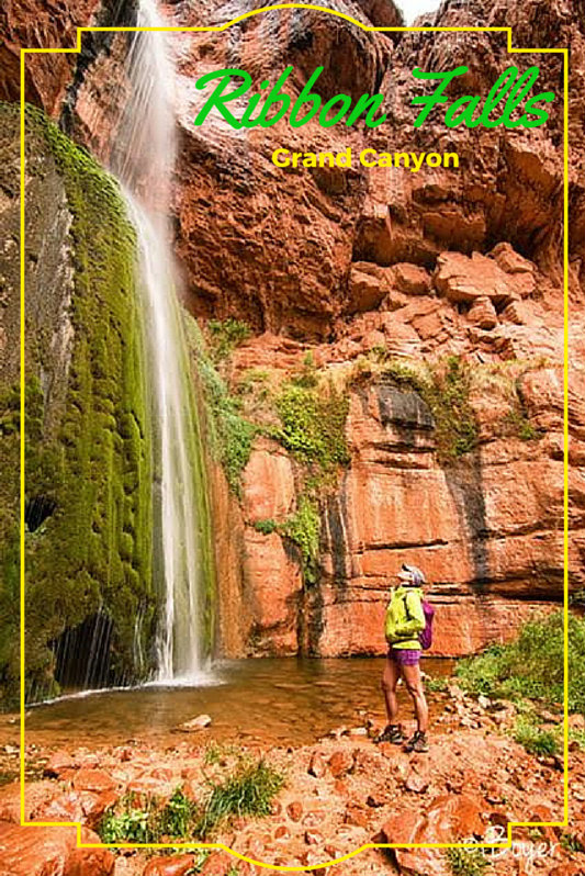
On Day 2 of our Grand Canyon backpacking trip, we woke up at 5 a.m. to begin our day hike to Ribbon Falls, located about 6 miles from Bright Angel Campground along the North Kaibab Trail. Despite the steady rain all day, the conditions made Ribbon Falls even more stunning, with mist and flowing water enhancing the dramatic scenery.

Ribbon Falls stands approximately 140 feet tall and features a unique travertine spire formed by mineral-rich water over time. Water flows down into two distinct pools—one at the base and another about halfway up the formation, roughly 50 feet above ground. While swimming is allowed here, the chilly 45°F temperatures and constant rain made that a no-go for us!

You can hike beneath and around the waterfall, offering an incredible up-close view. Although reaching Ribbon Falls requires careful planning and a valid Grand Canyon backcountry permit, the 2.5-hour hike from Bright Angel Campground is absolutely worth it.

Arizona

Backpacking the Bright Angel Trail, Grand Canyon National Park

Backpacking the Bright Angel Trail in Grand Canyon National Park

Backpacking the Bright Angel Trail in Grand Canyon National Park (GCNP) had been one of my top bucket list goals for years. I first visited the Grand Canyon about six years ago, but I wasn’t able to hike below the rim because I had my dog with me (note: dogs are not allowed below the rim). While I could enjoy the scenic overlooks, I never got a true sense of just how deep, wide, and awe-inspiring the canyon really is. I knew I had to return—this time, to explore it from within.

Arizona

Horseshoe Bend, Page, Arizona, Glen Canyon Recreation Area

Horseshoe Bend is one of my favorite overlooks in the U.S. Horseshoe Bend is along the Colorado River, and is only 3 miles south of Page, Arizona along Highway 89, 5 miles downstream from the Glen Canyon Dam, and requires a 3/4 mile walk to the overlook. The 1,000 ft drop to the bottom offers fantastic views, and if you have a wide angle lens or panorama option, you can capture the full horseshoe-shaped river and canyon.

Arizona

Monument Valley, Utah, Arizona, Monument Valley Wildcat Trail

Visiting Monument Valley Navajo Tribal Park – Scenic Drive & Wildcat Trail Hike

Our Day Trip from Goosenecks State Park

On our first full day exploring Southeastern Utah, we crossed the state line into Arizona to visit Monument Valley Navajo Tribal Park. From our base camp at Goosenecks State Park, the drive took just 45 minutes—an easy and scenic route.

When planning our trip, we initially considered taking a guided tour. However, due to budget constraints, we looked into self-guided options instead. It’s important to note that Monument Valley regulations prohibit visitors from leaving their vehicles on the scenic drive to hike around iconic formations like the Mittens—unless accompanied by a Navajo guide or holding a permit..

Thankfully, we discovered that one trail is open to the public without a guide: the Wildcat Trail, a must-do if you're exploring the area on a budget or prefer hiking at your own pace.

Arizona

Black Mesa Indian Ruins

My Thanksgiving weekend was spent with my parents in Phoenix, AZ, and instead of shopping on Black Friday, we wanted #OptOutside and explore an area they had heard about called the Black Mesa Indian Ruins. Hundreds, and maybe thousands, of people drive by the "trail head" every day, but not many know that there are 800 year old ruins sitting on top of the mesa. I put "trail head" in quotes because there's not really a trail - just route finding through thick cactus.

error: Content is protected